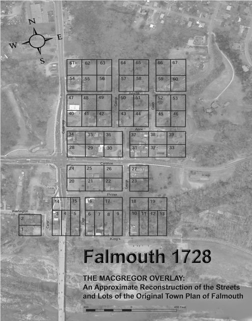
MacGregor Overlay
The MacGregor Overlay is displayed on a modern aerial photograph of Falmouth, showing roughly where the town’s original streets and lots would be located today.
In 1728, the Falmouth town trustees sold 27 lots to various individuals. More sales quickly followed. Almost immediately, the new owners subdivided their lots, selling or leasing small parcels to others who wished to establish stores, tradesmen’s stands or dwellings. Often, these parcels were only slightly larger than the tiny structures built on them. Building codes were nonexistent. Within a few years, many of the lots were packed with buildings. Lot lines were lost or altered; small, unused streets were absorbed into yards; new alleys were created to provide access to structures at the rear of the lots; and many of the original lot numbers became irrelevant. It appears that these numerous lot subdivisions and other changes so muddled the original lot numbering scheme that, around 1929 or 1930, Stafford officials completely re-numbered all of the parcels in the town. Like the earlier surveys, no hard copy of either the old or the new plan seems to survive. It will be noticed that there are no numbered lots marked along most of the west side of what is today U.S. Route 1. It appears that Warner included a road, which is now Cambridge Street/Route 1, that ran northward out of town and parallel to the ravine formed by Falls Run, but he seems not to have placed any lots on its west side.
By the nineteenth century, as a Civil War era map indicates, structures had been built on the west side of Cambridge Street. Eventually, commercial and residential buildings on that side of the road became familiar landmarks in Falmouth. By 2015, however, road widening and other factors had led to the removal of many buildings in that area.