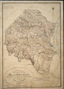
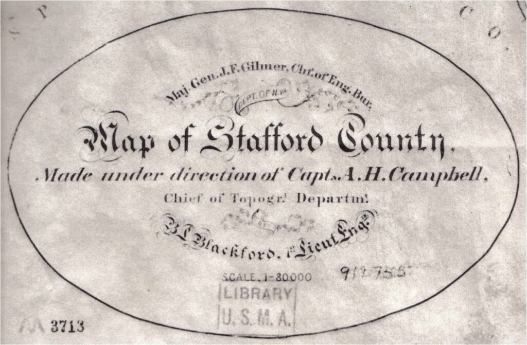
Gilmer-Campbell Map
One of the best “Come Retribution”-related documents is one of the so-called “Gilmer-Campbell” maps. The principal actors were Maj. Gen. Jeremy Gilmer, chief of the Confederate Engineers Bureau; Captain A. H. Campbell, chief topographic engineer in the bureau and topographic engineer for Lee’s Army of Northern Virginia; and Lieutenant B. Lewis Blackford, topographic engineer. Their Stafford-specific story was:
- On August 21, 1864, Blackford (in Wilmington, NC) was ordered to report to Campbell in Richmond (Special Order 196 A&IGO). Blackford reported on September 1st.
- On September 2nd, Campbell ordered Blackford to “proceed as soon as possible with your party to resume the Survey of Stafford County… After completing Stafford secure as much as possible of the county of Prince William, and Fauquier as far north as the Orange and Alexandria Railroad.”
- Although encumbered by sickness and other obstacles, Blackford’s survey party worked through October to complete the map. Blackford personally surveyed the Potomac River shore. Avoiding several brushes with Federal patrols, the other 15 men (20 percent of the Confederate topographic engineers) completed their work.
- On October 25th, Blackford was ordered by Campbell to King William County to map main routes from Caroline County to Hanover Junction [now Doswell], Hanover Court House, Taylorsville and Ashland. Campbell adds Gilmer was “still anxious about Stafford.”
- Blackford was instructed to complete his work by October 31st, and “on completing your map of Stafford report with it, in person, to this headquarters.”
Crucially, Stafford had no military strategic value at this time. Confederates had moved south into the Richmond defenses in May and June. Federals had shifted their main logistics centers from Aquia and Belle Plain Landings in June. For what purposes were these maps intended?
- After finishing his Stafford map, Blackford mapped routes in King William and Caroline Counties and then in King George and Hanover Counties. At the end of the war (April 1865) he was mapping the area near Danville, Virginia, “the last capital of the Confederacy,” where Lee intended to link up with Joseph E. Johnston’s Army of Tennessee to fight on after the evacuation of Richmond.
- During this period of Confederate “Black Flag” warfare actions it was thought that the kidnappers of President Lincoln would spirit him to the Richmond area (through Stafford) to be exchanged. “Covering forces” were drawn from reliable Northern Neck units in Barton’s Brigade, Custis Lee’s Division, to provide military reinforcement along potential movement routes.
Years later General Gilmer’s daughter presented this map to her father’s alma mater, the United States Military Academy at West Point. Stafford County Historical Society members Steve Gambaro and Milton Ford made photographic copies as an example of Civil War topography and local wartime history. It is now clear that the map represents a great deal more as a document of the Confederacy’s last desperate weeks.